Why should we use computers to simulate earthquakes?
The Taiwan Numerical Earthquake Model (TNEM) was developed by Dr. Shiann-Jong Lee (李憲忠), associate research fellow at the Institute of Earth Sciences of Academia Sinica. This model can accurately and quickly analyze the process by which earthquakes occur to bring further understanding to historical earthquakes of the past, current earthquakes that took place recently, and future earthquakes that have yet to happen. This type of comprehensive, in-depth, and accurate understanding offers important contributions to disaster prevention.

Dr. Shiann-Jong Lee, an associate research fellow at the Institute of Earth Sciences of Academia Sinica, employs supercomputers to study past, present, and potential future earthquakes in Taiwan.
Photography | Chang-yu Chen
In the wee hours of September 21, 1999, the Jiji earthquake (also known locally as the 921 earthquake) attacked without warning and shook the Taiwanese awake from their dreams. As one of the deadliest quakes recorded in the history of Taiwan, any mention of the 1999 Jiji earthquake still brings back dreadful and painful memories for many locals.
At that time, Dr. Shiann-Jong Lee was a first year student in his doctoral program. Soon after entering the study of seismology, he was tremendously shocked and greatly affected by the Jiji earthquake. In the aftermath of the quake, Dr. Shiann-Jong Lee realized that the field of seismology in Taiwan was one that not only required further research but an area that needed the involvement of more scholars and researchers. If enough time and effort were put into thoroughly researching and understanding the Chelungpu fault (車籠埔斷層),* then maybe the worst of the Jiji Earthquake could have been prevented and averted.
*This 1999 earthquake, named after its center in the urban township of Jiji in central Taiwan, occurred along the Chelungpu fault, which stretches along the foothills of the Central Mountains in Nantou County and Taichung.
Well over a decade later, in the early hours of February 6, 2016, another earthquake (known as the 2016 Southern Taiwan earthquake or the Meinong earthquake) shook the island while all of Taiwan was in deep slumber. This earthquake wreak havoc in the city of Tainan, causing serious casualties throughout.
This time around, Dr. Shiann-Jong Lee was able to use the Taiwan Numerical Earthquake Model (TNEM) that he developed to unravel the mystery behind this earthquake. Encompassing a set of numerical models, the Taiwan Numerical Earthquake Model takes advantage of leading computing technology to offer insight on earthquakes of the past, present, and future. This powerful tool can greatly advance efforts in earthquake and disaster prevention.
With the earthquake centered in Meinong, why did Tainan take the hardest hit?
The earthquake that struck Taiwan on February 6, 2016 was an utterly brain-wracking phenomenon that left many experts confused and scratching their heads. The earthquake epicenter was clearly located in the Meinong District in Kaohsiung. Yet, why was the worst felt in the city of Tainan, a municipality located north of Kaohsiung?
This is not an easy question to answer if we rely solely on the observation data collected by the Central Weather Bureau in Taiwan. The weather bureau can only provide basic values such as the location, magnitude, and seismic intensity of earthquakes, but it cannot tell us what actually happened beneath the surface deep under the ground.
The computer numerical simulation model devised by Dr. Shiann-Jong Lee delves deep underground and reconstructs the movements of faults in relation to one another as well as their overall subsurface slip distribution to understand the special characteristics of earthquakes and their process of formation and occurrence.
As shown in the following figure, Dr. Shiann-Jong Lee calculated the subsurface slip distribution of faults for the quake centered in Meinong. Based on his calculations, Dr. Shiann-Jong Lee’s data offers a breakthrough explanation regarding mystery behind the 2016 Southern Taiwan earthquake: His discovery shows that the fault ruptured most seriously and severely not within the vicinity of the epicenter (demarcated with a red star). Instead, the rupture was the most severe northwest of the epicenter where there are two apparent asperities (marked in the figure below by the two red circles), which are areas that are part of the geological fault line that are either stuck or locked.
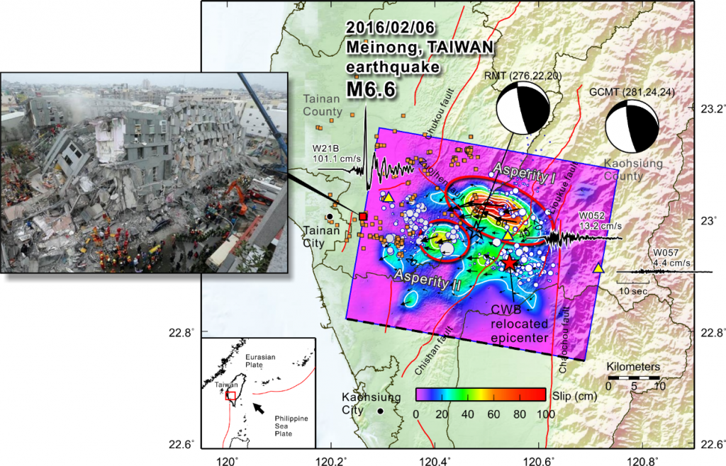 On February 6, 2016, an earthquake with the magnitude of 6.6 struck near the Meinong District in Kaohsiung. From the analysis provided by the Taiwan Numerical Earthquake Model, it can be seen that northwest of the epicenter (denoted by a red star), there are two asperities (marked by red circles). These two asperities are the main reason why the major disaster areas of the 2016 Southern Taiwan earthquake were located northwest of the earthquake epicenter in the region of Tainan.
Source | Provided by Shiann-Jong Lee
After the fault rupture started in the epicenter, it extended northwestwards towards the Tainan area. This type of effect in quakes is called directivity, which is the focusing of wave energy along the fault in the direction of rupture where the radiated waves are stronger in one direction along the fault.
The direction of the rupture is not necessarily the direction of the fault. Because of the different characteristics of each earthquake, it is necessary to use the observation data in combination with computing analysis to reverse engineer and reconstruct what exactly happened with the faults beneath the ground.
During the 2016 Southern Taiwan earthquake, Dr. Shiann-Jong Lee explained that there were other factors at play that affected the rupture process and seismic wave propagation. Seismic site effect, which is related to the amplification of seismic waves in geological layers, is one of these other factors. The temblor and surface ground motion may be strongly amplified if the geological conditions of the area are unfavorable, and damage due to an earthquake may thus be aggravated.
The 2016 Southern Taiwan earthquake struck in the Chianan Plain or Jianan Plain (嘉南平原)—an alluvial plain located at the central-southern region of western Taiwan. As the largest plain on the island, it spans across the city of Tainan as well as the city and county of Chiayi, from which the name of the plain was derived. The Jianan Plain features relatively loose and unconsolidated soil or sediments. Thus, the sediment layers are relatively soft and loose, contributing to the amplification of seismic waves and compounding the severity of the earthquake. Furthermore, the energy of seismic waves continued to oscillate in the loose sediments within the geological layers, prolonging the period of shaking during the earthquake.
https://www.youtube.com/watch?v=eLDovQhJuq0Computer simulation of the 2016 Southern Taiwan Earthquake via the Taiwan Numerical Earthquake Model (TNEM)
The above video is an animation that Dr. Shiann-Jong Lee created simulating the three-dimensional seismic wave transmission using the Taiwan Numerical Earthquake Model based on data collected from the Southern Taiwan earthquake that took place on February 6, 2016.
As can be seen from the animated simulation, due to the seismic site effect, the vibrations caused by seismic wave transmission were more severe in the Jianan Plain than in the mountain areas. In addition, the earthquake source itself was also impacted by a source radiation effect, which means that the vibrations extending to different directions from the epicenter are not all uniform. They are instead distributed based on the radiation pattern and directivity. During the 2016 Southern Taiwan earthquake, the area in which the radiation pattern was amplified is exactly west of the Meinong epicenter in Tainan, the area most severely affected by the quake.
All of the above factors taken in combination help explain the confusing phenomenon behind the 2016 Southern Taiwan earthquake—showing how it is possible that while the epicenter was in Meinong, Tainan bore the brunt of the devastation.
What is so extraordinary about the Taiwan Numerical Earthquake Model (TNEM)?
Dr. Shiann-Jong Lee and his research team were able to reconstruct and simulate what happened beneath the surface during earthquakes using a powerful tool that they developed on their own—the Taiwan Numerical Earthquake Model (TNEM). But what is so special about this model?
The Taiwan Numerical Earthquake Model (TNEM) is an integrated model. This model employs computer technology to simulate and reconstruct large-scale earthquakes in Taiwan, analyzing the process of source rupture and the three-dimensional seismic wave transmission.
The simulation of ruptures from the earthquake source is based on abduction or abductive reasoning. Through feeding far-field data (from the global and world network), near-field data (Taiwan’s own seismic data), and coseismic surface GPS displacement data to the computer, the model then reconstructs earthquakes depicting the time and spread of the slip distribution in the faults. Then, using the readily built and established source rupture model in combination with the three-dimensional numerical model of the underground geological structure, TNEM is then able to simulate the complex structure of the transmission of seismic waves during earthquakes.
Another notable feature of this model is that it has also developed an important system that is able to calculate and provide earthquake reports in real time.
In just two seconds, the supercomputer can analyze the 400,000 grids located across the island of Taiwan to find the exact location of the earthquake source and all the source parameters. With the help of computer technology, the time, location, scale, and focal mechanism of earthquakes can be explained within two minutes. This report, in particular the analysis of the focal mechanism of earthquakes, can now be made available much faster than through the traditional earthquake reporting system.
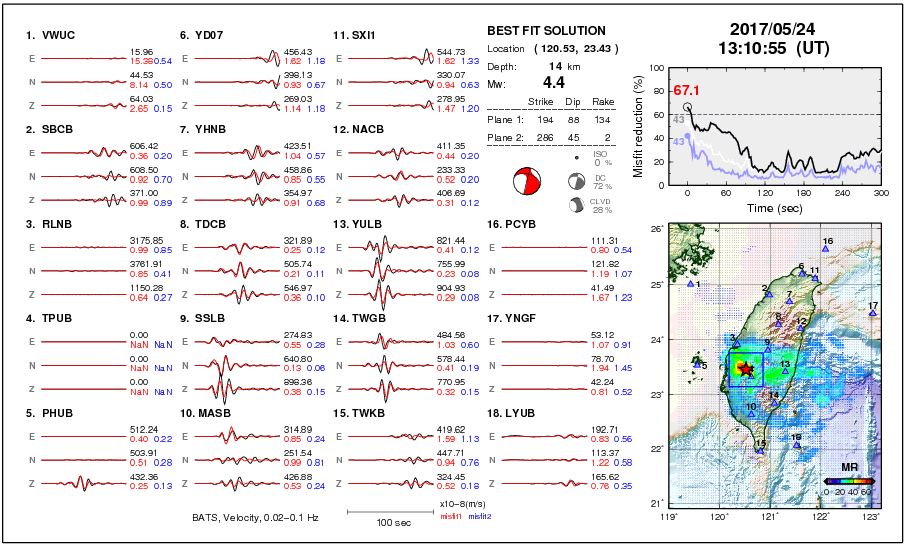 The black lines are actual seismic observations made at monitoring stations located throughout Taiwan, and the red lines are values based on computer model simulations of earthquakes. When the two lines closely overlap and are largely superimposed on one another, it means that an earthquake has occurred in the area. When an earthquake hits, the Real-Time Moment Tensor Monitoring System (RMT) site will immediately display the position of the epicenter, seismic parameters, and other related data.
Image source | Real-Time Moment Tensor Monitoring System
The waves shown in the earthquake monitoring system are normally seen are background noise, but as soon as an earthquake takes place, complete information regarding the quake will be determined and displayed in two minutes. Dr. Shiann-Jong Lee said with confidence that this earthquake monitoring system is definitely one of the best in the world. Updating its information every two seconds, the Real-Time Moment Tensor Monitoring System (RMT) website is available and open for public access.
Why is it possible for Taiwan to build and establish this type of state-of-the-art real-time earthquake monitoring system?
Dr. Shiann-Jong Lee stated that the project was made possible due to many reasons. For one, overall Taiwan is relatively small in size, and the government in Taiwan supports related research. As a result, the seismic observation network in Taiwan may very likely be the largest and the most densely populated in the world. What is even more important is that his team of researchers developed an inclusive software system to analyze earthquakes that uses the 256 CPUs available at the Institute of Earth Sciences at Academia Sinica for continuous and long-term monitoring.
This seismic monitoring model is also world-class for another reason. It fully adopts and uses the three-dimensional underground geological structure for its calculations. Dr. Shiann-Jong Lee said that many foreign research teams hypothetically construct underground geological structures based on a homogeneous or one-dimensional tectonic structure. Although this type of assumption allows researchers to quickly determine the approximate pattern of earthquakes, it also has its limitations. The composition of nature is not uniform or one-dimensional; thus, such simple structures perpetuate misjudgments and/or errors in calculations and analysis.
Dr. Shiann-Jong Lee hopes to use high-precision seismic models to establish various numerical databases of simulation results and then use them as the basis and foundation for long-term scientific research and disaster prevention applications. Therefore, the more accurate the data, the better it is.
Nature is a complex three-dimensional environment that is definitely not one-dimensional. Unless the underground tectonic structure and composition of the area in question are very simple, simple structures will not be applicable. Based on my understanding, I believe it is safe to guess that the geological makeup in earthquake prone areas are generally quite complicated. With the gradual advancement of computer technology, computational three-dimensional velocity structures will become increasingly influential, to the point where they become a necessary and routine task in our line of work.
1935 Hsinchu-Taichung earthquake—reconstructing historical earthquakes
The Taiwan Numerical Earthquake Model not only can accurately analyze recent earthquakes, it can also reconstruct historical earthquakes from the past and produce simulations of earthquakes that may occur in the future.
Although historical earthquakes are a thing of the past, understanding the course and special characteristics of these past disasters is very important for future disaster prevention. When seismic energy in the fault accumulates to a certain extent, it may once again release its “energy” in the form of another earthquake. If we can understand its recovery cycle and the rupture characteristics, we can better grasp how to prevent the next major earthquake.
The Hsinchu-Taichung earthquake that struck in 1935 resulted in more casualties than the 1999 Jiji earthquake and is to date recorded as the worst earthquake that rattled the island. A current sightseeing destination in Miaoli County, the Yutengping Bridge (魚藤坪斷橋), also known as the Longteng Bridge, is a relic left behind by this tragic earthquake.
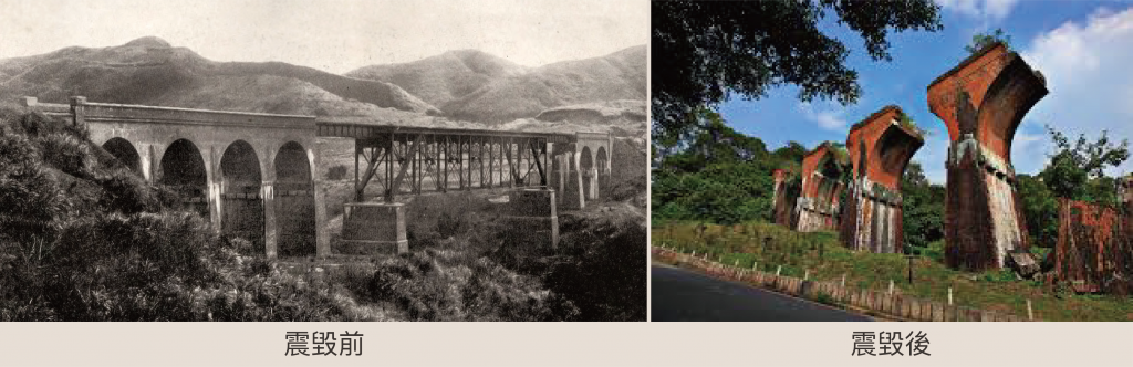
The Yutengping Bridge (魚藤坪斷橋) in Miaoli was damaged beyond repair by the 1935 Hsinchu-Taichung earthquake. In the aftermath of this devastating earthquake, the broken bridge became a cultural relic and a sightseeing destination. In 1999, the Jiji earthquake caused one of the remaining piers, the upper part of No. 4 pier, to also collapse. As a result, the county government decided to rededicate the bridge’s remains as a monument to remember the two deadliest earthquakes in Taiwan’s history. The site was also named as one of Taiwan’s cultural heritage assets.
Source | Wikipedia
Image Source | Taiwan shashincho (臺灣寫真帖, A Picture Album of Formosa), Volume 1 and Wang Qi ( 王崎)
Image reproduction | Chang-yu Chen
Since that was a period long before the advent of the digital era, it is difficult to obtain seismic data for the 1935 Hsinchu-Taichung earthquake. What remains chiefly available are recordings made by the Japan Meteorological Agency. The earthquake record at that time was analogous and used a recording pen to take down the process of vibration on smoked paper that served as the recording sheet. Records of the degree of severity were generally rendered based on the observations and oral accounts of local residents. Judgments were made based either on subjective feelings regarding the quake or the degree of damage on houses and buildings. As such, there may be large discrepancies in terms of the records and exactly what happened at the time.
Now that we have a numerical seismic model at our disposal, it is possible to simulate the situation by reconstructing the earthquake. This method can greatly help us understand historical earthquakes of the past.
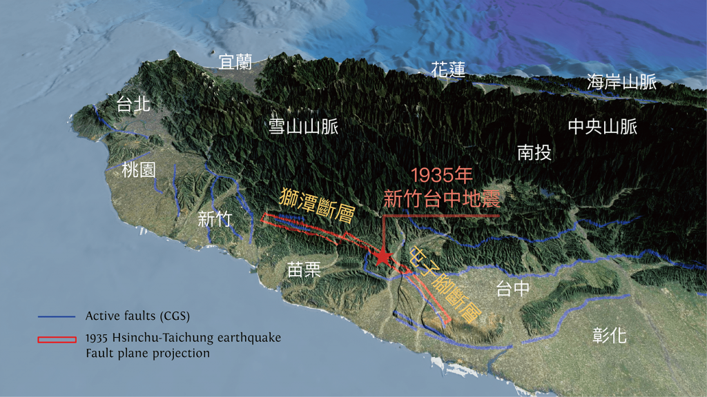 In 1935, when the Hsinchu-Taichung earthquake struck, it ruptured from the epicenter towards both the north and south. To the north was the Shihtan Fault, and to the south was the Tuntzuchiao Fault.
Source | Provided by Shiann-Jong Lee
| 台北 | Taipei |
| 桃園 | Taoyuan |
| 宜蘭 | Yilan |
| 新竹 | Hsinchu |
| 雪山山脈 | Xueshan Range (雪山山脈) |
| 獅潭斷層 | Shihtan fault (獅潭斷層) |
| 苗栗 | Miaoli |
| 花蓮 | Hualien |
| 1935 年 新竹台中地震 | 1935 Hsinchu-Taichung earthquake |
| 屯子腳斷層 | Tuntzuchiao fault (屯子腳斷層) |
| 南投 | Nantou |
| 台中 | Taichung |
| 海岸山脈 | Coastal Mountain Range (海岸山脈) |
| 中央山脈 | Central Mountain Range (中央山脈) |
| 彰化 | Changhua |
The 1935 Hsinchu-Taichung earthquake broke out in two directions from the epicenter towards both the north and the south. To the north of the earthquake center was the Shihtan Fault (獅潭斷層), and to the south was the Tuntzuchiao Fault (屯子腳斷層). The geological structure of the western part of Taiwan is composed of folds and thrusts with many north-south running faults. The 1935 earthquake was a result of the shattering of one of these faults, which in turn triggered the rupture of other faults. Prompting a domino effect, and the range and scope of rupture elongated and became rather large and extensive.
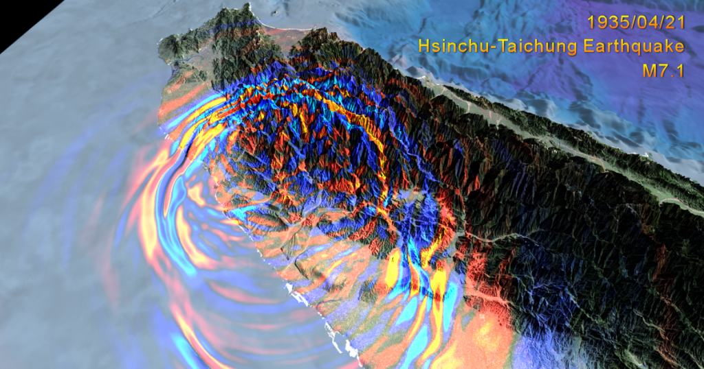 The directionality of this earthquake can be clearly seen from this computer simulation. The figure shows that degree of severity on the northern side is larger than the southern side, and the range of strong vibrations is also more extensive. This was exactly the case during the 1935 Hsinchu-Taichung earthquake. Compared to the southern side of the epicenter, the earthquake more drastically affected the area along the northern side of the epicenter, which is Hsinchu and Miaoli. These simulation results are reasonably consistent with the records at the time.
Source | Provided by Shiann-Jong Lee
Foreseeing and understan
ding future earthquakes before they strike
Dr. Shiann-Jong Lee said that as a seismologist, he is often asked the following question by friends and relatives: “Can you actually predict earthquakes?” Across the island, there are unusual individuals who claim to be able to accurately predict earthquakes. Yet, based on his experience, Dr. Shiann-Jong Lee clarified that to truly predict and forecast earthquakes, there are three key factors that must be explicitly defined—time, location, and scale. To date, this type of earthquake prediction which explicitly states these factors is still not yet possible in the realm of science.
Although it is impossible to predict earthquakes, numerical simulations can analyze different scenarios. This makes it possible to delve into the different types of earthquakes and understand their structure, composition, and characteristics, including the distribution of its tremors, ultimately allowing us to prepare for and prevent disasters before the earthquake strikes.
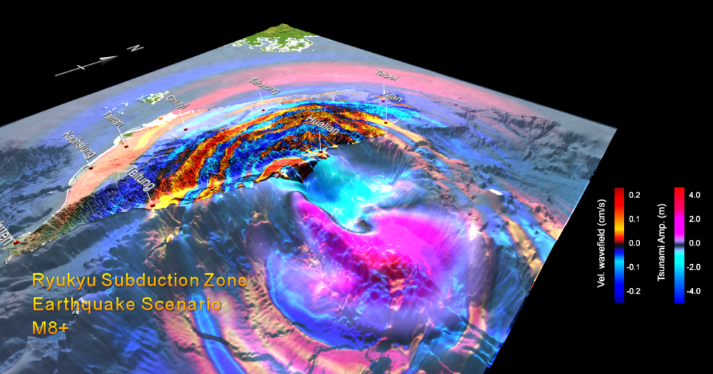 The above simulated results portray a hypothetical large-scale megathrust earthquake with a magnitude of 8.0 or above in the Ryukyu Trench. The simulation shows both the surface velocity wavelength of the seismic wave and the height of the tsunami wave.
Source | Provided by Shiann-Jong Lee
The above figure demonstrates Dr. Shiann-Jong Lee’s hypothetical simulation of a worst-case scenario, with what can be considered potentially the most severe and dangerous earthquake that can assault Taiwan.
Situated in the eastern part of Taiwan is the Ryukyu Trench, also known as the Nansei-Shoto Trench. It is located along the southeastern edge of Japan’s Ryukyu Islands in the Philippine Sea in the Pacific Ocean, between northeastern Taiwan and southern Japan. The trench is a convergent plate boundary that formed as a result of the oceanic crust of the Philippine Plate subducting obliquely beneath the continental crust of the Eurasian Plate, where one tectonic plate is forced underneath another. This trench extends directly to Japan. Megathrust earthquakes that may occur in this subduction zones at such destructive convergent plate boundaries are usually extremely large in magnitude, with the possibility of exceeding 8.0 in scale. These interplate earthquakes are considered the planet’s most powerful and destructive.
Dr. Shiann-Jong Lee comments that Japan has done a superb job in terms of earthquake disaster prevention. However, the Great East Japan Earthquake that struck on March 11, 2011 still took them by surprise. At the time, seismologists estimated that it would be an approximately 8.0 earthquake. They did not at all expect the magnitude of the earthquake to reach 9.0 and above. As a result, Japan was not prepared for the large-scale earthquake that struck off Japan’s northeastern shore—the most powerful earthquake ever recorded to have hit Japan—generating enormous tsunami waves that spread across miles of shoreline.
Learning from the Great East Japan Earthquake, we must not underestimate our opponent. Computer technology can aid us in simulating powerful terrestrial sources of tectonic activity that produces earthquakes of this scale.
If a large-scale earthquake were to occur at the subduction zone in the Ryukyu Trench, we would not only have a powerful earthquake to contend with but also a destructive tsunami to deal with. The simulation of potential tsunamis is tremendously important because tsunami waves travel at a much slower rate than the seismic waves of earthquakes. The speed of the seismic wave is approximately 6 to 8 kilometers per second while the tsunami travels at only 0.2 to 0.3 kilometers per second.
Three to four minutes after the earthquake hits, seismic waves would have spread all across the island of Taiwan, but tsunami waves in comparison requires two or three hours. Therefore, tsunamis can indeed be predicted as they offer early warnings. Based on these characteristics, before the tsunami becomes powerful and destructive, there should be enough time for evacuation after the earthquake.
How does the numerical simulation provide guidelines for disaster prevention?
The numerical simulation of earthquakes can provide a plethora of information that aids disaster prevention. Before a earthquake hits, this model can analyze the distribution of the disaster area and scale of the disaster should the earthquake hit. This type of detailed information is especially helpful for making assessments for disaster prevention and control.
For specific areas that are especially earthquake prone, the numerical simulation model can be used to study the trends of active faults and the directionality of blind faults—faults that do not break through to the surface anywhere along their length. Delving into this type of research, experts can look at various factors including the potential rupture directions and seismic site effect. All of these findings can be applied to seismic design to build earthquake resistant infrastructure and to implement more comprehensive building regulations.
In addition, when the earthquake occurs, various parameters of the earthquake can be quickly pinpointed and defined by the Real-Time Moment Tensor Monitoring System (RMT). As far as the earthquake source is concerned, the focal mechanism can be quickly obtained to estimate which fault may be related or may have triggered the earthquake as well as to assess whether it will affect adjacent faults. If the tectonic activity of the fault has yet to cease and seismic activity still continues, special attention must be paid to whether there will be an aftershock or if an even bigger earthquake is to follow.
Moreover, real time online seismic simulation can quickly calculate the distribution of seismic wave propagation and seismicity and in turn infer in which areas the disaster would be the most serious. Disaster relief personnel can be dispatched accordingly.
The results obtained from the Taiwan Numerical Earthquake Model are numerical simulations grounded in the foundations of physics and are fairly accurate in predicting future events that have yet to take place. Its predictions are very close to “real situations that may occur in the natural world in the future”.
At present, disaster prevention agencies have their own sets of earthquake and disaster response procedures. The current system is mainly based on statistics, using factors including “scale, seismic intensity, and population density” to form logic trees to assess the severity and size of disasters. In the future, as the Taiwan Numerical Earthquake Model becomes more comprehensive, it can then be used to complement and even strengthen the current earthquake disaster assessment system and provide new and effective applications.